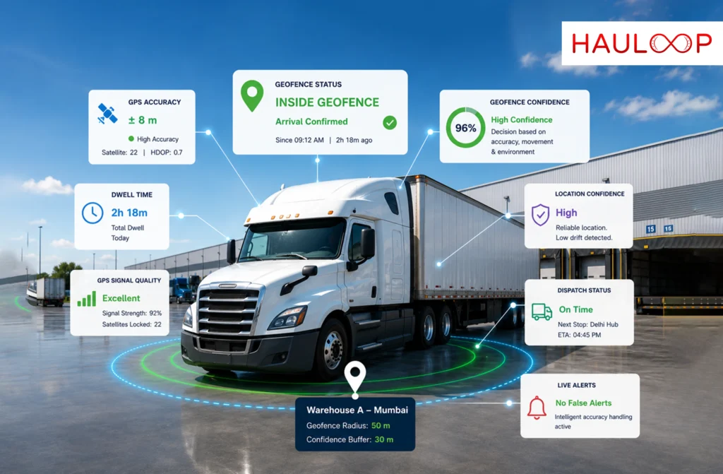
Fleet geofencing has become one of the most widely used features in modern fleet management systems. It powers automated arrival and departure updates, delivery confirmations, dwell-time calculations, dispatch workflows, customer notifications, and SLA reporting.
Yet many fleet operators experience the same frustrating problem.
A truck arrives at a warehouse and remains parked for two hours. Instead of recording one arrival and one departure, the fleet management system generates dozens of entry and exit notifications. Dispatchers begin questioning drivers, delivery timestamps become inaccurate, and automated workflows stop being trusted.
The vehicle never moved.
The GPS hardware wasn’t faulty either.
The real problem lies in how the fleet tracking system interprets GPS data.
Traditional fleet geofencing assumes every GPS coordinate represents the vehicle’s exact position. In reality, every GPS reading includes an accuracy margin that changes continuously depending on the surrounding environment.
Intelligent GPS accuracy handling solves this challenge by understanding the confidence behind every GPS reading instead of treating every coordinate as the absolute truth. The result is more reliable GPS fleet tracking, fewer false geofence alerts, and smarter dispatch automation.
Why Traditional Fleet Geofencing Often Produces False Alerts?
Most GPS tracking software follows a very simple rule.
If the vehicle is inside the geofence:
Arrival
Else:
Departure
While this approach appears logical, it ignores one important fact:
GPS locations are estimates, not exact points.
Every GPS coordinate has an uncertainty range that may vary from a few metres to more than fifty metres, depending on operating conditions.
GPS accuracy is influenced by:
- Buildings and warehouse structures
- Urban environments
- Satellite visibility
- Weather conditions
- Device quality
- Signal strength
For example:
| Operating Environment | Typical GPS Accuracy |
| Rural highways | ±5–10 m |
| Urban streets | ±20–30 m |
| Warehouse docks | ±40–60 m |
This means a stationary truck positioned inside a 50-metre geofence may appear to move outside the boundary simply because the reported GPS position shifts within its normal accuracy range.
The GPS receiver is behaving exactly as expected.
The fleet management system simply interprets uncertain data as certain.
How GPS Drift Creates False Geofence Events?
Imagine a truck parked at a warehouse for 90 minutes.
The geofence radius is 50 metres.
GPS accuracy fluctuates around ±40 metres.
Although the vehicle remains stationary, the reported coordinates move slightly around the boundary.
Instead of recognising this as normal GPS behaviour, a conventional geofencing system records:
Inside
Outside
The result is dozens of false operational events.
Dispatch teams may receive:
- Multiple arrival notifications
- Incorrect departure alerts
- False delivery completions
- Incorrect dwell-time calculations
- Wrong ETA updates
- Misleading SLA reports
Eventually, operators lose confidence in the alerts and return to manual phone calls or WhatsApp updates.
The issue isn’t poor GPS tracking.
It’s poor geofence logic.
How Intelligent Fleet Geofencing Solves the Problem?
Modern fleet geofencing does much more than compare a coordinate with a circle on a map.
Instead, it evaluates several factors before confirming an entry or exit event.
A reliable system considers:
- GPS accuracy
- Vehicle movement
- Previous geofence state
- Time consistency
- Operating environment
Only when all these conditions support the decision does the platform trigger an operational event.
Rather than reacting to every GPS coordinate, the platform asks:
“Is the vehicle confidently inside or outside the geofence?”
That simple difference dramatically reduces false alerts.
Accuracy-Aware Entry and Exit Logic
Instead of using only the geofence radius, intelligent systems calculate a confidence boundary.
For example:
| Parameter | Distance |
| Geofence radius | 50 m |
| GPS accuracy | ±30 m |
| Safety buffer | 20 m |
| Safe exit distance | 100 m |
Instead of triggering an exit immediately at 50 metres, the system waits until the vehicle has moved beyond the full confidence threshold.
Coordinates that fall within the uncertainty zone are treated as ambiguous rather than definite movement.
This prevents normal GPS drift from triggering unnecessary dispatch actions.
Why Hysteresis Makes Geofencing More Reliable?
Another important improvement is hysteresis.
Rather than using one boundary for both entry and exit, the platform applies different confirmation thresholds.
If the vehicle is already inside the geofence, it must move well beyond the boundary before an exit is confirmed.
If the vehicle is outside, it must move confidently inside before recording an arrival.
This small change prevents the repeated “inside-outside-inside” behaviour commonly seen near geofence boundaries.
Instead of constantly switching states, the platform waits for genuine movement.
Adapting Geofencing to Different Operating Environments
Not every delivery location behaves the same.
Warehouse docks, highways, urban delivery points, and rural collection sites all experience different GPS conditions.
An intelligent fleet management system adapts its geofence behaviour accordingly.
| Environment | Recommended Behaviour |
| Warehouse dock | Larger confidence margin, longer confirmation |
| Urban delivery | Medium confirmation period |
| Highway | Faster confirmation |
| Rural location | Fine-grained geofence accuracy |
A warehouse may require a longer confirmation period because satellite signals are partially obstructed.
A highway, where GPS accuracy is much higher, can respond much faster.
This allows the platform to remain accurate without simply making every geofence larger.
Four Layers Behind Intelligent GPS Fleet Tracking
Reliable geofence tracking combines four technology layers.
Layer 1 – GPS Accuracy Estimation
Every GPS reading includes an estimated confidence level based on:
- Signal quality
- Satellite lock
- Device accuracy
- Environmental conditions
Layer 2 – Smart Boundary Logic
Instead of using fixed distances, the platform calculates dynamic entry and exit thresholds based on current GPS accuracy.
Layer 3 – Environmental Adaptation
Warehouse docks, cities, highways, and rural roads each receive different geofence behaviour based on expected GPS performance.
Layer 4 – Operator Visibility
Dispatchers receive more than a simple arrival alert.
Each event includes:
- GPS confidence
- Timestamp
- Vehicle location
- Distance from boundary
- Recommended action
Real-World Comparison
Consider the same warehouse scenario.
| Approach | Result |
| Basic geofence logic | 47 false entry and exit alerts |
| Larger geofence workaround | Fewer alerts but reduced precision |
| Intelligent GPS accuracy handling | One arrival and one departure with no false events |
The truck never changed.
The GPS device never changed.
Only the software logic changed.
That difference determines whether fleet automation becomes dependable or frustrating.
Why Reliable Geofencing Matters for Fleet Operations?
Accurate vehicle geofencing is about much more than knowing where a truck is.
Reliable geofence events become triggers for connected operational workflows, including:
- Delivery confirmation
- Dispatch automation
- Route progress tracking
- Customer ETA updates
- Dwell-time measurement
- Billing milestones
- SLA monitoring
- Driver handovers
- Exception management
When the geofence event is reliable, the entire workflow becomes reliable.
When the event is wrong, every downstream process is affected.
How to Evaluate GPS Fleet Tracking Software?
When comparing fleet tracking solutions, don’t just ask whether geofencing is available.
Ask how it works.
| Question | Why It Matters |
| Does the platform use GPS accuracy information? | Reduces false alerts |
| Does it apply different entry and exit thresholds? | Prevents repeated state changes |
| Does it support hysteresis? | Improves reliability near boundaries |
| Does it adapt to different environments? | Better performance at warehouses and cities |
| Can it automate high-confidence events? | Reduces manual intervention |
| Are confidence levels visible? | Helps dispatchers trust the system |
These questions separate basic GPS tracking software from intelligent fleet management platforms.
Conclusion
Reliable fleet geofencing is not about drawing better circles on a map.
It is about understanding how GPS behaves in real operating environments and making smarter decisions from that data.
By combining GPS accuracy handling, hysteresis, environmental adaptation, confidence scoring, and intelligent decision logic, fleet operators can dramatically reduce false alerts while improving dispatch automation, SLA reporting, customer communication, and operational visibility.
The result is an AI fleet management system that operators trust rather than work around.
When dispatchers stop questioning every geofence alert, they spend less time validating data and more time managing fleet operations.
That is what intelligent GPS accuracy handling is designed to achieve.
Book a demo to see how Hauloop delivers reliable fleet geofencing, intelligent GPS fleet tracking, and connected dispatch automation across real-world logistics operations.
Frequently Asked Questions
Why do stationary vehicles trigger multiple geofence alerts?
GPS readings naturally fluctuate within an accuracy range. Without accuracy-aware logic, a stationary vehicle can appear to repeatedly cross the geofence boundary.
What is accuracy-aware geofencing?
It evaluates GPS accuracy, movement consistency, environmental conditions, and previous vehicle state before confirming entry or exit events.
What is hysteresis in fleet geofencing?
Hysteresis uses different thresholds for entry and exit, preventing vehicles from repeatedly switching states when GPS readings fluctuate near the boundary.
Can intelligent geofencing improve dispatch automation?
Yes. Reliable geofence events support automated delivery confirmations, ETA updates, dwell-time tracking, billing milestones, and SLA monitoring.
Should fleets simply increase geofence size?
Not necessarily. Larger geofences reduce precision and may capture nearby locations. Accuracy-aware logic improves reliability while maintaining accurate operational boundaries.
What should I look for in a fleet geofencing solution?
Look for GPS accuracy handling, hysteresis, environmental adaptation, confidence scoring, operator visibility, and integration with dispatch and fleet management workflows.